Detecting Lost Field Boundaries: Three Small Experiments to Read Human Footprints in the Landscape
Many rural landscapes still carry the ghostly imprint of past land use: medieval ridge-and-furrow, enclosure banks, terrace lines, and abandoned hedgerows. These features persist because human activity alters soil, stone distribution, and vegetation in ways that can survive centuries. Understanding how to spot and verify them with simple, repeatable experiments is a useful skill for naturalists, local historians, and anyone curious about the deeper story of a place.
What you will build: a working map of hidden boundaries
Across three progressively more invasive experiments you will: 1) learn to spot candidate features from surface clues, 2) test those clues with systematic soil and vegetation measurements, and 3) confirm and interpret the feature with a small, careful excavation. Each step can stand alone, but together they produce a robust, field-tested hypothesis about whether a line in the landscape is natural or an old human-made boundary.
Experiment 1 — Visual and vegetation survey (non-invasive)
Objective: identify candidate boundary lines using slope, stone, and plant indicators.
Materials: notebook, camera or phone, measuring tape (10 m), compass, disposable gloves.
- Choose a 100–200 m stretch where you suspect an old boundary (field edges, tree lines, or abrupt changes in vegetation).
- Walk along the potential line at roughly 5–10 m intervals. At every interval record: slope (flat, banked, or terrace), surface stones (clustered, aligned, or absent), dominant plants (grasses vs. shrubs), and soil color visible at the surface. Photograph each spot and note GPS coordinates or rough bearings.
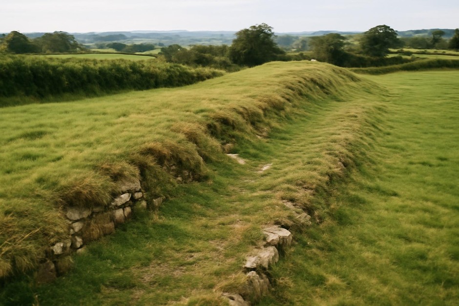
- Look for telltale visual cues: straight or subtly curving linearity, raised banks with a ditch on one side, aligned stone concentrations, or a narrow band of woody species where surrounding land is open pasture.
- Interpretation: a consistent raised profile, aligned stones, and woody regeneration strongly suggest an anthropogenic boundary (bank, stone wall line, or former hedgerow). Random stones or isolated trees are less convincing.
Experiment 2 — Soil- and vegetation-transect measurements (minimally invasive)
Objective: quantify differences across the candidate line to test whether the feature is a persistent soil/vegetation boundary.
Materials: soil probe or stout rod, small trowel, tape measure, flagging tape, clipboard.
- Select a 10–20 m transect perpendicular to the candidate line. Mark points every 1 or 2 m across the transect with flagging tape.
- At each point, probe to 20–30 cm if possible and note soil resistance (easy, moderate, hard), depth to stones, and topsoil color/texture. For a quick organic matter proxy, scrape a small area and smell/check for crumbly dark topsoil vs. pale subsoil.
- Record vegetation height and dominant species at each point; note abrupt shifts in species composition. Measure any raised profile height across the transect with the tape measure.
- Interpretation: a sharp change in soil depth or texture, a concentration of stones under the raised side, or a narrow band of thicker topsoil are strong evidence of an anthropogenic bank or terrace. Natural transitions are usually more gradual and lack consistent stone concentrations.
Experiment 3 — Small confirmation pit (controlled, careful)
Objective: expose a short vertical profile to confirm if the line is a constructed bank, buried wall footing, or a natural mound.
Materials: small spade/trowel, measuring tape, notebook, camera, bucket for spoil, gloves; obtain landowner permission and follow local regulations.
- Choose a discrete 0.5 x 0.5 m or 1 x 0.5 m test pit on the suspected raised feature, ideally where Experiments 1 and 2 showed the strongest signals.
- Excavate carefully in levels (5–10 cm) and document the sequence: color changes, compacted layers, abrupt stone layers, or dark organic bands. Photograph faces and note depths to any stone concentrations or buried topsoils.
- Interpretation: a constructed bank often shows alternating fill layers, compacted clays, or a sudden appearance of wall stones. Buried topsoil with charred or cultural material would indicate past occupation or sustained human activity.
- Refill the pit and restore the surface to avoid erosion and comply with land-use ethics.
Putting it together: map the line from your observations and mark confidence: visual-only (low), transect-supported (medium), pit-confirmed (high). Historic maps, old aerial photos, and local knowledge can be consulted afterward to strengthen interpretation, but these three experiments give you a practical, repeatable field method to detect and read long-hidden boundaries. Done carefully, the approach connects a living landscape to the human actions that shaped it centuries ago.