Thawing Ground: Comparing Yedoma and Peatland Permafrost — Materials, Mechanisms, and Measurement
Opening observation: Permafrost is not a uniform material. Beneath tundra and boreal landscapes, two very different frozen archives—yedoma and peatland permafrost—preserve organic matter in contrasting physical matrices. Those contrasts shape how the ground thaws and how scientists can study it. A close look at materials and methods clarifies trade-offs in interpretation and measurement.
1. Materials and internal structure: loess-rich yedoma versus organic peat
At the material level, yedoma and peatland permafrost are distinct.
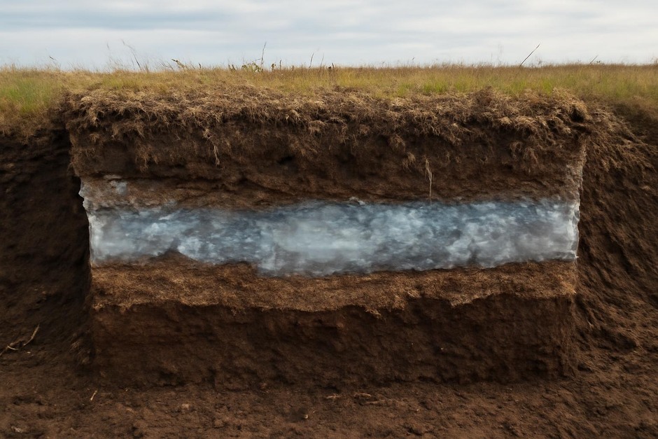
- Yedoma: Typically found in Siberia, Alaska, and Yukon, yedoma consists of ice-rich silty loess with dispersed plant and animal remains. Large ice wedges and massive ice bodies are common, and the solid fraction includes mineral grains bound with frozen organics. The ice content can exceed 50% by volume in some deposits.
- Peatland permafrost: In contrast, peatland permafrost is dominated by partially decomposed plant material—peat—forming a high-porosity, fibrous organic matrix. Ice is present in pore spaces and as segregated ice, but the bulk material is organic rather than mineral.
These material differences influence thermal properties, hydraulic behavior, and mechanical strength. Yedoma’s mineral framework gives it higher thermal conductivity and often abrupt collapse upon thaw, while peat’s low thermal conductivity and high water-holding capacity lead to different thaw morphologies.
2. Thaw mechanics and morphological outcomes
How these materials respond to warming or disturbance depends on structure and ice content.
- Yedoma thaw is commonly associated with rapid, retrogressive thermokarst: thawing of ice-rich units causes subsidence and slope retreat when ice wedges and massive ice melt. The mineral-organic mix can slump, exposing fresh material and accelerating erosion.
- Peatland thaw often proceeds more diffusely. Surface peat can dry and oxidize in drained conditions, while inundation and gradual permafrost degradation can convert peat plateaus into bogs or collapse scar wetlands. The fibrous peat may compress rather than slump dramatically.
In short, yedoma favors abrupt landscape transformation; peat favors progressive hydrological change—both with implications for hydrology, vegetation, and carbon release pathways.
3. Measurement approaches: field and laboratory methods
Studying these systems requires a suite of complementary methods, each with advantages and limitations.
- Soil cores and exposures: Direct sampling via cores or natural/engineered exposures provides material for physical description, radiocarbon dating, and lab incubations. Cores deliver high-resolution stratigraphy but are logistically heavy, risk thaw artifacts during extraction, and are spatially limited.
- Geophysical techniques: Ground-penetrating radar (GPR), electrical resistivity tomography (ERT), and seismic surveys map subsurface structure noninvasively. They are excellent for identifying ice-rich layers and thermokarst geometry over larger areas but require calibration with core data and can struggle in very conductive (waterlogged) peat.
- Remote sensing: Airborne LiDAR and satellite imagery track surface elevation changes and thermokarst progression. These methods reveal landscape-scale patterns and temporal trends but do not directly resolve subsurface composition.
- Gas flux measurements: Chambers and eddy-covariance towers quantify CO2 and CH4 exchange. They capture ecosystem-scale emissions but integrate across heterogeneous patches; attributing fluxes to specific subsurface processes often needs supporting soil and hydrological data.
- Laboratory incubations: Incubating frozen or thawed samples under controlled conditions reveals potential decomposition rates and product ratios. These experiments isolate material properties but abstract away field hydrology, microbial interactions, and scale effects.
Combining methods—cores to ground-truth geophysics, remote sensing to contextualize point measurements, and flux towers to link subsurface changes to atmospheric exchange—yields the most robust inferences, but logistical costs and site accessibility constrain how comprehensively that combination can be applied.
4. Methodological trade-offs in monitoring and modeling
Designing observation networks and models involves trade-offs between resolution, scale, and interpretability.
- High-resolution, localized studies (e.g., repeated coring, in situ sensors) resolve processes in detail but may misrepresent regional heterogeneity.
- Large-scale remote monitoring captures spatial variability and long-term trends but often lacks the material-specificity needed to distinguish yedoma from peat responses or to quantify stored carbon pools precisely.
- Experimental manipulations such as warming plots or hydrological interventions reveal causal mechanisms but can alter boundary conditions and are labor-intensive to maintain.
Modelers must decide how to parameterize heterogeneous materials: representing yedoma as discrete ice-rich units with potential for abrupt subsidence versus treating peatland permafrost as a continuum with hydraulic coupling leads to different modeled outcomes. Each choice reduces complexity but may omit relevant feedbacks.
Measured conclusion
Yedoma and peatland permafrost are distinct in material composition and thaw behavior, and those distinctions shape suitable measurement strategies. No single method suffices: cores and lab work reveal material properties; geophysics and remote sensing establish spatial context; flux measurements connect subsurface change to ecosystem exchange. The appropriate mix depends on research questions and logistical constraints. Appreciating trade-offs—between resolution and coverage, disturbance and authenticity, process detail and scalability—helps researchers design studies that accurately characterize both the frozen materials and the mechanisms that will transform them.